1/19


NextGIS Mobile
1K+ေဒါင္းလုဒ္မ်ား
23MBအရြယ္အစား
2.9.1(30-01-2025)နောက်ဆုံး ဗားရှင်း

အေသးစိတ္မ်ားျပန္လည္သံုးသပ္မႈမ်ားဗားရွင္းမ်ားအချက်အလက်
1/19
NextGIS Mobile ၏ ရွင္းလင္းခ်က္
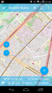
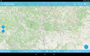
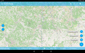
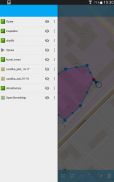
NextGIS မိုဘိုင်းကြောင်းတတ်နိုင်သမျှသင့်မိုဘိုင်း device ကိုများအတွက်ပထဝီသတင်းအချက်အလက်စနစ်တစ်ခုဖြစ်ပါသည်:
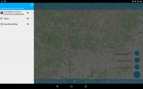
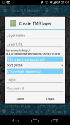
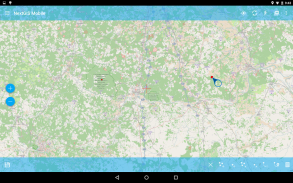
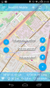
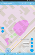
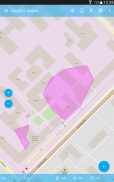
- ပြပွဲ Multi-layer ကိုမြေပုံ (အလွှာအွန်လိုင်းနှင့်အော့ဖ်လိုင်းရင်းမြစ်များမှလာနိုငျသညျ)
- အပြောင်းအလဲမြင်ကွင်းနှင့်အလွှာအမိန့်
- (ချုံ့, အားပွတ်ဆွဲထဲမှာချဲ့) မြေပုံလမ်းညွှန်
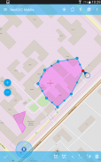
- ပြင်ဆင်ရန်အားနည်းချက်ကိုဒေတာ (ဂျီသြမေတြီနှင့် attribute တွေနှစ်ဦးစလုံး) အွန်လိုင်းနှင့်အော့ဖ်လိုင်း
- စံချိန်ပုဒ်
- ပြပွဲကိုသြဒီနိတ်, အမြန်နှုန်းမြင့်စသည်တို့ကို
NextGIS Mobile - ဗားရွင္း 2.9.1
(30-01-2025)ဘာအသစ္ရွိလဲSupport for spaces in field names

ေကာင္းမြန္ေသာအက္ပ္ျဖစ္ေၾကာင္း အာမခံသည္ဤအက္ပ္သည္ ဗိုင္းရပ္စ္၊ ေမးလ္၀ဲႏွင့္ အျခားမသမာေသာ တိုက္ခိုက္မႈမ်ားအတြက္ လံုၿခံဳေရးစစ္ေဆးခ်က္ကို ေအာင္ျမင္ခဲ့ၿပီး မည္သည့္အႏၲရာယ္မွ် မရွိပါ။
NextGIS Mobile - APK သတင္းအခ်က္အလက္
APK ဗားရွင္း: 2.9.1package: com.nextgis.mobileအမည္: NextGIS Mobileအရြယ္အစား: 23 MBေဒါင္းလုဒ္မ်ား: 51ဗားရွင္း : 2.9.1ျဖန္႔ခ်ိသည့္ ရက္စြဲ: 2025-01-30 05:30:47စခရင္အေသး: SMALLအေထာက္အပံ့ေပးနိုင္ေသာ စီပီယူ: x86, x86-64, armeabi-v7a, arm64-v8a
ပက္ေက့ဂ်္အိုင္ဒီ: com.nextgis.mobileSHA1 လက္မွတ္: 98:7C:B6:CF:A5:A2:14:1C:D1:0F:8E:13:AD:2A:50:BA:9B:D8:8F:2Eထုတ္လုပ္သူ (CN): Dmitry Baryshnikovအဖြဲ႕အစည္း (O): NextGISေဒသဆိုင္ရာ (L): Moscowနိုင္ငံ (C): RUျပည္နယ္/ၿမိဳ႕ေတာ္ (ST): Russiaပက္ေက့ဂ်္အိုင္ဒီ: com.nextgis.mobileSHA1 လက္မွတ္: 98:7C:B6:CF:A5:A2:14:1C:D1:0F:8E:13:AD:2A:50:BA:9B:D8:8F:2Eထုတ္လုပ္သူ (CN): Dmitry Baryshnikovအဖြဲ႕အစည္း (O): NextGISေဒသဆိုင္ရာ (L): Moscowနိုင္ငံ (C): RUျပည္နယ္/ၿမိဳ႕ေတာ္ (ST): Russia
NextGIS Mobile ၏ ေနာက္ဆုံးဗားရွင္း
2.9.1
30/1/202551 ေဒါင္းလုဒ္မ်ား23 MB အရြယ္အစား
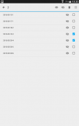
အျခား ဗားရွင္းမ်ား
2.9.0
26/1/202551 ေဒါင္းလုဒ္မ်ား23 MB အရြယ္အစား
2.8.0
3/10/202451 ေဒါင္းလုဒ္မ်ား23 MB အရြယ္အစား
2.7.1
24/7/202451 ေဒါင္းလုဒ္မ်ား22.5 MB အရြယ္အစား
2.7.0
11/7/202451 ေဒါင္းလုဒ္မ်ား22.5 MB အရြယ္အစား
2.6.56
11/6/202451 ေဒါင္းလုဒ္မ်ား19.5 MB အရြယ္အစား
2.6.52
29/1/202451 ေဒါင္းလုဒ္မ်ား19.5 MB အရြယ္အစား
2.6.49
27/8/202351 ေဒါင္းလုဒ္မ်ား19 MB အရြယ္အစား
2.6.48
21/6/202351 ေဒါင္းလုဒ္မ်ား15 MB အရြယ္အစား
2.6.46
24/5/202351 ေဒါင္းလုဒ္မ်ား15 MB အရြယ္အစား


Age of Apes 3.55
3.55
3.55

X-Samkok3.17
3.17က႑တူအက္ပ္မ်ား

သင္ႏွစ္သက္ႏိုင္သည္မ်ားမွာ...

English


